
Storm System Targets the Archipelago
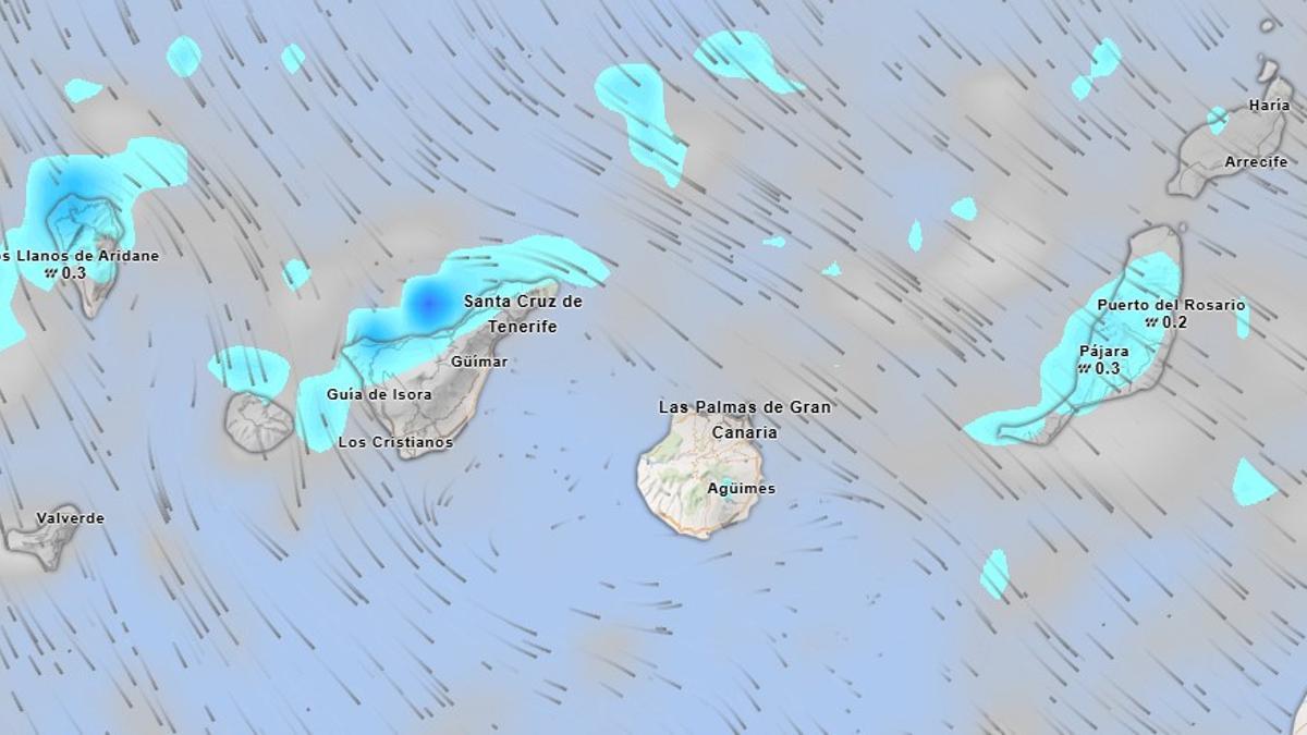
The Canary Islands face a new episode of meteorological instability this Thursday, with Tenerife one of the islands most affected by a passing storm. The State Meteorological Agency (Aemet) forecasts rain, falling temperatures, and very strong wind gusts across the archipelago. Aemet predicts weak to moderate rain in the north of the mountainous islands, while the rest of the Canaries will see cloudy intervals and occasional showers.
This situation will be compounded by a drop in maximum temperatures and a moderate northwesterly wind, which will shift to a northeasterly direction throughout the day. The wind will be one of the most adverse elements of this episode, with a particular impact on the summits and the eastern and western slopes of the islands.
Tenerife and Gran Canaria Bear the Brunt
In Tenerife, Aemet warns that occasionally very strong gusts are more likely over the central summits, the Dorsal Ridge, and the Cañadas del Teide, where wind intensity could create risky situations. In the north of the island, skies will be cloudy with weak to moderate rain, which could be locally persistent, especially in mid-altitude areas. These showers will tend to ease in the afternoon, with breaks in the cloud along coastal zones.
Elsewhere on the island, cloudy intervals will give way to overcast skies in the south during the afternoon, when occasional showers cannot be ruled out. Temperatures will remain largely unchanged, with slight dips in the maximums. The northwesterly wind will gradually shift to northeast during the middle of the day, intensifying in the far northeast, the western slope, and especially in high areas, where very strong gusts are expected before losing intensity by the end of the day. In Santa Cruz de Tenerife, thermometers will read between 16 and 21 degrees.
In Gran Canaria, the north will see cloudy skies with weak to moderate rain, possibly persistent in mid-altitude areas. The rest of the island will experience cloudy intervals with a low probability of showers in the south. The wind will be a moderate northwesterly, with strong gusts in high areas and exposed slopes.
Conditions Across the Eastern and Western Isles
Lanzarote and Fuerteventura will start the day with cloudy skies and weak to moderate rain during the early hours and morning, tending towards clearer skies as the day progresses. Both islands can expect slight drops in maximum temperatures and a northwesterly wind turning north, with the possibility of strong gusts inland and in the Jandía peninsula.
In La Gomera, La Palma, and El Hierro, the north will be the area most affected by precipitation, with weak to moderate rain that could be persistent in mid-altitude areas. The wind will also be a key feature on these islands, with strong gusts on summits and exposed slopes, before diminishing by the end of the day.
Maritime Warnings and Safety Advice
At sea, a west, northwest, and north wind of force 3 to 5 is expected, increasing locally to 5 or 6, with a moderate or rough sea state. Furthermore, there will be a north or northwest swell with waves of around two metres and the possibility of occasional downpours in the north of the archipelago.
Aemet recommends taking extreme caution due to the combination of rain, strong winds, and rough seas, especially in the high areas of Tenerife and on the most exposed northern slopes of the archipelago.
No post found!