
Coastal Pre-Alert Activated Across the Canary Islands
The Government of the Canary Islands has maintained a pre-alert for coastal phenomena across the entire archipelago, anticipating a significant worsening of sea conditions. The measure, enacted by the Directorate General for Emergencies, came into force at 2:30 pm on Sunday, 21 December. It follows warnings issued by the State Meteorological Agency (Aemet) and the activation of the Canary Islands Specific Emergency Plan for Adverse Meteorological Risks (PEFMA).
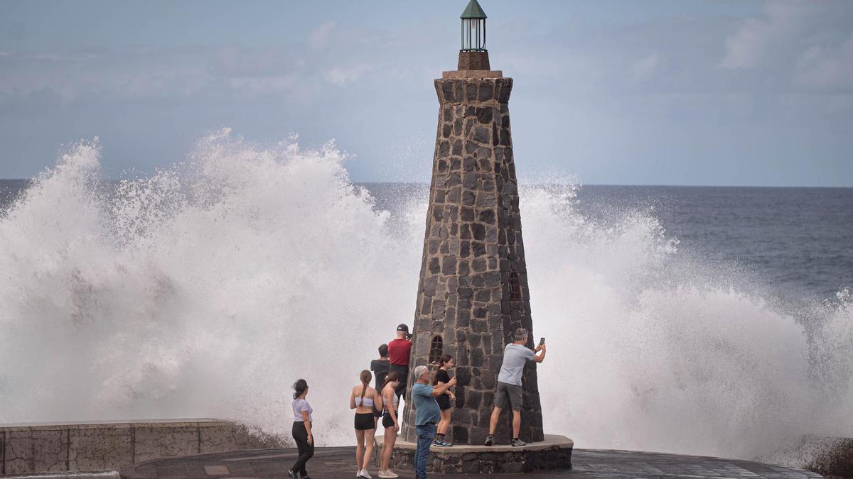
Affected Coastlines and Forecast Conditions
The situation affects the north and west coasts of Tenerife, as well as extensive stretches of the Canary Islands’ shoreline, necessitating extreme caution, particularly for sea-related activities, navigation, and exposed coastal areas. The pre-alert covers a large part of the archipelago’s coasts, specifically:
- The west, north, and northeast coasts of La Palma and Lanzarote.
- The north and west coasts of El Hierro, La Gomera, and Tenerife.
- The north and west coasts of Fuerteventura.
- Areas of the northwest and north of Gran Canaria.
In these areas, poor sea conditions are forecast, with a combined swell that could reach between 2 and 4.5 metres, accompanied by moderate to strong winds. During Monday, northeasterly winds of force 4 to 5 (between 20 and 38 km/h) are expected, with local intervals of force 6 in the latter half of the day. The sea will be rough, developing into very rough conditions, with a northwesterly ground swell of between 3 and 4 metres. The significant wave height of the combined swell will be between 3 and 4.5 metres, coinciding with high tidal coefficients, which increases the risk in exposed coastal zones.
Adverse Conditions to Persist into Tuesday
On Tuesday, winds are expected to gradually ease, shifting from the northeast to a northerly component overnight. Despite this, adverse conditions will persist, with rough and very rough seas between Tenerife and Gran Canaria, as well as between Gran Canaria and the south of Fuerteventura. The ground swell will remain between 2 and 3 metres, with more pronounced waves during the early hours, advising continued caution.
Yellow Warnings Issued and Public Advice
The adverse maritime conditions have led Aemet to activate yellow-level warnings for waves in the Canaries, especially in Lanzarote, where waves could reach up to five metres. Across mainland Spain, adverse weather has prompted warnings in eight autonomous communities and the autonomous city of Melilla, primarily for snowfall, heavy rain, low temperatures, and strong waves.
The regional government stresses the importance of following self-protection recommendations, including:
- Avoiding walks along promenades, breakwaters, and rocky areas.
- Not undertaking nautical or sporting activities in exposed areas.
- Heeding the instructions of Civil Protection and local councils.
- In an emergency, calling 112.
No post found!