Satellite Images Reveal Tenerife Wildfire Damage
Open Cosmos, a leading international space technology company recently established at Tenerife’s Science and Technology Park, has captured striking satellite images of the forest fire that broke out on Monday, July 28 in El Tanque municipality. The images were taken just hours after Tenerife’s local government announced the blaze was under control.
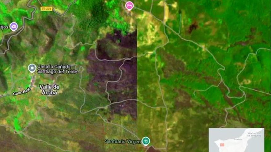
Precision Mapping of Burned Areas
The Hammer satellite’s high-resolution images clearly show the 80-hectare affected area spanning El Tanque and Santiago del Teide municipalities. At 4:49 PM on Monday, the satellite passed over the island and generated data used to create a false-color map precisely outlining the fire’s perimeter. This technology proves invaluable for damage assessment and coordinating recovery efforts efficiently.
The Canary Islands Constellation Project
While this particular mission wasn’t commissioned by Tenerife’s government, the rapid acquisition of detailed images strengthens the island’s strategy to develop its own satellite network. The ambitious Canary Islands Constellation project, developed in collaboration with the Canary Islands Astrophysics Institute (IAC), represents a €20 million investment in cutting-edge space technology.
Leadership Perspectives on Satellite Potential
Tenerife President Rosa Dávila emphasized: “This mission demonstrates the future constellation’s capabilities – providing immediate, reliable data tailored to our territory, crucial for risk prevention and effective emergency response.” Innovation Councilor Juan José Martínez added: “Open Cosmos proves high-resolution images available within two hours, with usable products in just five minutes, are game-changers for wildfire management.”
Advanced Monitoring Capabilities
The Canary Islands Constellation will deploy a network of small satellites providing daily coverage of Tenerife, La Palma, La Gomera, and El Hierro. The system will collect visible, infrared, and thermal data with high resolution, featuring the DRAGO-3 camera – a €2.2 million modular device developed in the Canaries with 10-meter per pixel resolution. This technology will enable fire surveillance, crop monitoring, pollution control, and tracking of coastal/volcanic risks.
Tenerife’s Growing Space Sector
Martínez highlighted Open Cosmos choosing Tenerife as its operational base: “This strengthens our position in Europe’s space ecosystem and confirms our potential to develop cutting-edge environmental and security technology.” The initiative marks progress toward smarter, autonomous civil protection models using real-time, locally-adapted data.